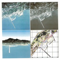
Since the 58th year of the Republic of China (1969), the Joint Commission on Rural Reconstruction (JCRR), the Council for International Economic Cooperation and Development (CIECD), and other units involved in economic development agreed that to accelerate economic construction and improve the economic growth rate, it was essential to leverage aerial surveying technology to expedite the creation of large-scale basic maps for economic planning.
As a result, it was decided that Director General Mao Yingchu (毛瀛初) of the Civil Aeronautics Administration (CAA) would lead the initiative. Renowned domestic experts in aerial surveying, including Zhang Ruzhen (張汝珍), Shi Huishun (史惠順), Liao Daniu (廖大牛), Xie Renxin (謝仁馨), Hua Boqun (華伯群), and Guo Yanshou (郭延壽), were invited to establish the Aerial Survey Development Center. Mr. Ge Jinshao (葛錦召) from the JCRR was appointed as the executive secretary, and American aerial surveying experts H.L. Slattum and L.A. Woodward were invited to assist in formulating the development plan. However, due to unforeseen circumstances, the establishment of the Aerial Survey Development Center was ultimately abandoned. As a result, some personnel originally engaged in aerial surveying joined the Service Department of the Chinese Forestry Association to continue their work in the field.
In 1978 (the 67th year of the Republic of China), after the reestablishment of the Chinese Society of Photogrammetry and Remote Sensing (CSPRS), aerial surveying personnel officially joined the society’s Service Department. Concurrently, the society actively expanded its operations by acquiring new instruments and equipment. Over the years, it undertook various projects commissioned by public and private organizations, completing numerous maps of Taiwan, thematic maps, and large-scale aerial survey topographic maps.
Starting in 1991 (the 80th year of the Republic of China), the society advanced into digital photogrammetry, developing standards and training technical personnel in the field. In March 1991, it completed Taiwan’s first 1:1000 digital photogrammetric topographic map, covering Taipei City. This milestone spurred the digitization of topographic mapping for major projects such as Taipei City developments, the Second Freeway, and the High-Speed Rail.
In July 1994(the 83th year of the Republic of China), commissioned by the Department of Land Administration of the Ministry of the Interior and the Taiwan Provincial Government Land Administration Office, the society digitized over 38,000 maps from Taiwan’s national land use survey. This effort sparked a surge in the application of geographic information systems (GIS). In August of the same year, the society was further commissioned by the Department of Land Administration to produce 1:1000-scale digital photogrammetric topographic maps for cadastral resurvey areas, marking a new chapter in cadastral mapping advancements.
Since its reestablishment, CSPRS has actively provided professional expertise and served the community. Currently, the technical services offered include:
1 | Production of digital imagery maps |
2 | Production of digital topographic maps of various scales |
3 | Production of digital topographic maps from aerial surveys |
4 | Survey of various land types and specific objects |
5 | Orthophoto map |
6 | Application of Satellite Positioning Systems (Security navigation survey) |
7 | Urban planning map production |
8 | Development of Geographic Information Systems (GIS) |
9 | Satellite image classification and application for various thematic maps |
10 | Multispectral data analysis and production |
11 | Digitization of cadastral maps |
12 | Reduction of various topographic maps |
13 | Ground surveying |
14 | Application of Web GIS |
15 | Land use survey |
Achievements Over the Years
© 2025 CSPRS Powered by LIVA CO., LTD.